• Northern Colorado Trail
    • NOCO Trail 2024
    • NOCO Trail Blog Overview
    • Colorado Trail 2023
    • CT Blog Overview
    • CDT 2021
    • CDT Blog Overview
    • Gear
    • AT 2018
    • AT Blog Overview
    • Gear
    • PCT 2016
    • PCT Blog Overview
    • Gear
    • Grays and Torreys
    • Bierstadt - Sawtooth - Evans
    • Long's Peak
    • Belford - Oxford - Missouri
    • Bierstadt
    • DeCaLiBron
    • Quandary Peak
    • Mount of the Holy Cross
    • BroLiDemCam
    • Elbert - Massive
    • La Plata
  • Off-Trail Gallery
    • Bierstadt Bloody Knee
    • PCT2016 Blister
    • About
    • Contact
Menu

Long Trails

All About The Adventure
  • Northern Colorado Trail
    • Northern Colorado Trail
    • NOCO Trail 2024
    • NOCO Trail Blog Overview
  • Colorado Trail
    • Colorado Trail 2023
    • CT Blog Overview
  • Continental Divide Trail
    • CDT 2021
    • CDT Blog Overview
    • Gear
  • Appalachian Trail
    • AT 2018
    • AT Blog Overview
    • Gear
  • Pacific Crest Trail
    • PCT 2016
    • PCT Blog Overview
    • Gear
  • 14ers
    • Grays and Torreys
    • Bierstadt - Sawtooth - Evans
    • Long's Peak
    • Belford - Oxford - Missouri
    • Bierstadt
    • DeCaLiBron
    • Quandary Peak
    • Mount of the Holy Cross
    • BroLiDemCam
    • Elbert - Massive
    • La Plata
  • Off-Trail Gallery
  • Bloody Pictures
    • Bierstadt Bloody Knee
    • PCT2016 Blister
  • Info
    • About
    • Contact
×

Day 78 - A Continuation. 1151.0 (21.3)

Kevin Silvernale January 7, 2017

Today would be a continuation of yesterdays ridge walk.  I did my best to not stop too many times, though I made sure I had a good view for lunch!  Also, I've heard from hikers going southbound that the last snow is at mile 1,225.  Though I've developed a rhythm to get through the snowy areas, it's going to be sweet relief when my feet stay dry all day.

Later in the day, I saw Irish Matt, a thru-hiker who has the same start date as myself. In fact, we rode in the same car to the trail head together.  He tells me his feet really hurt and he thinks something must be wrong with them.  Later we will find out, that was an understatement.  We chatted for a few minutes while enjoying a particularly good view, then talked as we hiked. There were many miles ahead before the end of the day.

It wasn't too long before we went back to hiking at our own paces, both of us figuring we'd see one another in a few hours at camp.  About 1.5 miles prior to my camp, I passed him and most of the group. I wanted to get to a ridge further ahead where I thought I would see a great sunset and sunrise.  Little did I know by walking ahead it would be the beginning of the group splitting up.  I would later find out Skinny Thor walked an additional 2-3 miles beyond me.

I encountered a swarm of mosquitoes in a rather damp area approximately .5 miles prior to camp.  Forcing me to run with my tired legs, I wonder if I made the correct choice in camping locations.  But at the top of the ski slope, I found my site and it had epic panoramic view of the valley below and of the sun setting behind the jagged ridges in the distance.

View fullsize 8545.JPG
View fullsize 8547.JPG
View fullsize 8548.JPG
View fullsize 8549.JPG
View fullsize 8554.JPG
View fullsize 8556.JPG
View fullsize 8555.JPG
View fullsize 8558.JPG
View fullsize 8559.JPG
View fullsize 8562.JPG
View fullsize 8564.JPG
View fullsize 8567.JPG
In Pacific Crest Trail Tags Donner Ski, Ski, donner pass, pct, Thru hike
Comment

View from Camp - End of Day 77

Day 77 - Tahoe Rim Trail. 1129.7 (18.9)

Kevin Silvernale January 6, 2017

The Tahoe Rim Trail is a 160 mile loop trail around Lake Tahoe.  A little later in the season, this trail becomes a hot spot for local and traveling hikers alike.  The PCT shares this trail around the west side of the lake before splitting off to the northwest.

A day of highlight views, good company and just a little bit of snow.  Having camped by myself last night, I didn't know if the group was in front of me or behind me.  The uncertainty forced me to come up with my own plan for the day.  

By mid day I had seen everyone from the group and it sounded like we all had similar plans as to where we wanted to make it by the end of the day.  Also, as we were sitting on a bench at a trail head parking lot, a thru-hiker (who's name I don't recall) sat resting when it came out that he was attempting to hike 40 miles this day.  Jaws in our laps, everyone around couldn't fathom hiking 40 miles in one day.  I had enough trouble hiking 25 without my body wanted to fall apart.

I took more breaks today than any day prior.  There were so many views I wanted to stop and sit at, it was my dad's birthday and I had cell service!  A great combination for not making miles.

In the evening, I did a bit of a body check and I noticed I was losing sensation in my middle two twos on both of my feet.  I figured it is from hiking more miles recently.  I saw not to much cause for concern.

Also, being it's my dad's birthday, I sent home a coffee mug from Kennedy Meadows back on Day 42 - Mile 702.2.  It was fun hearing about him opening it up.

View fullsize 8517.JPG
View fullsize 8518.JPG
View fullsize 8519.JPG
View fullsize 8520.JPG
View fullsize 8522.JPG
View fullsize 8524.JPG
View fullsize 8528.JPG
View fullsize 8529.JPG
View fullsize 8530.JPG
View fullsize 8533.JPG
View fullsize 8534.JPG
View fullsize 8535.JPG
View fullsize Day 42 - Kennedy Meadows
View fullsize 8536.JPG
In Pacific Crest Trail Tags Tahoe rim traile, south lake tahoe, pct
Comment

Day 76 - Dicks Pass. 1110.8 (20.8)

Kevin Silvernale January 5, 2017

Day 75 (1090.0) was a Zero day in South Lake Tahoe, and like most Zero days, I didn't take any pictures.  South Lake Tahoe is a really nice outdoors/mountain/ski town.  Filled with major grocery stores, a variety of restaurants and many tourists, I spent most of the day traveling around on foot to eat food or get food to eat later.

I get a bittersweet feeling every time I leave town.  Though the trail is not always fun, generally I'm pretty happy when I'm hiking.  That said, when leaving town, there are things that I tend to crave... such as a hot shower, ice cream or a bacon cheese burger.  Also, my pack is usually 15-25 pounds heavier when leaving town due to my food resupply.  Do I notice?  YES, yes I notice and it hurts to think about.  But as I think about it, I smile, because it's comical to do that type of thing to yourself time and time again and I know after 2 days of hiking, I will have consumed enough food for my backpack to feel comfortable.  That, my friends, is worth smiling over.

After having a fairly lazy morning, I packed up and went to a Starbucks to work on uploading what would be the last of my on trail blog posts, while the group finished packing their gear up.  Instead of calling a trail angel early on a weekend, we decided to try our luck hitch-hiking.  It didn't take too long before everyone had a ride back to the trail.

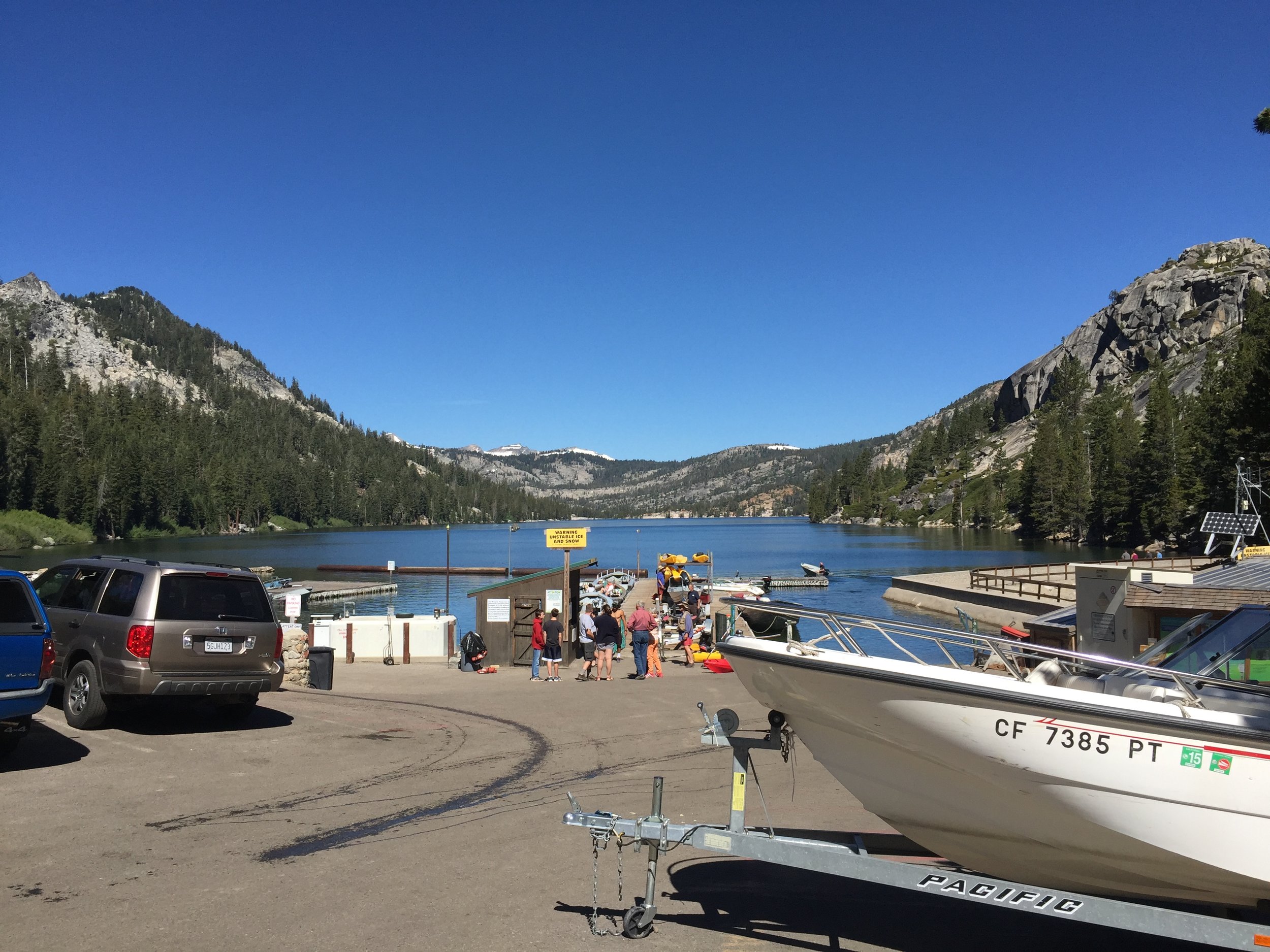
The first few miles lead to Echo Lake, a popular recreational lake located 30 minutes (driving) West of South Lake Tahoe.  I stopped with Mr. Clean and Backtrack to have a milkshake which I drank too quickly and gave myself brain freeze.  

While we enjoyed our cold beverage and soaked up the warm sun, a women was being dropped off by her husband and was getting back on trail (PCT).  Her name was Ranger and she had taken some time off to let her body recover.  She had also lost her hiking partner so she planned on camping with or near us this night.

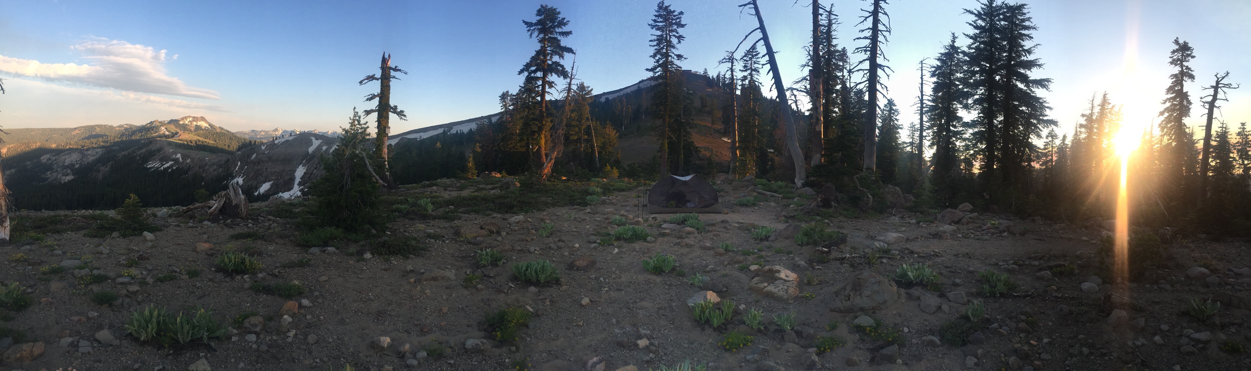
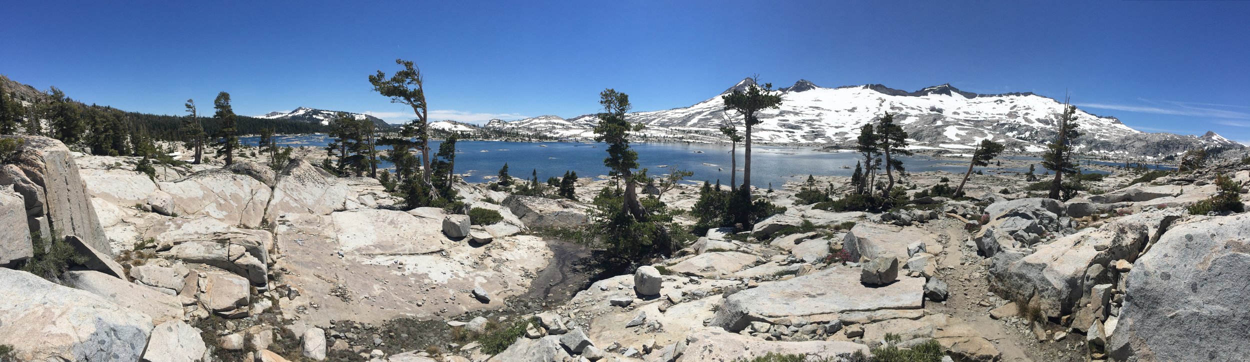
The many miles before Dicks Pass are littered with awe inspiring lakes, Aloha Lake being a highlight and where I chose to stop for lunch.  For the rest of the afternoon I walked by myself.  It was very warm causing the massive melt off to take of the trail.

As the trail climbed to Dicks Pass, the views got better and better.  At the top I had cell service where I managed to connect up with Butterfingers, who had just arrived in South Lake Tahoe.  Butterfingers, Early Bird and The Worm had gone into the Yosemite Valley from Tuolumne Meadows as many hikers did.  It was great knowing they had made it past the dangerous snow bridge (Day 67).  I suspected they would catch up with us eventually.

Also at the top of Dicks Pass, Ranger found good use of the last known cell service till who knows when.  When all was done, Ranger and I enjoyed the view then started our way down together.  The downhill side of Dicks Pass was quite difficult with enough snow that you couldn't avoid it, but it was very lose with lots of gaps between it and the ground.  Imagine walking on snow when you foot post-holes through to an awkward rock slightly twisting your ankle.  Over and over again.  This is what I mean by difficult.

Slowly, we worked our way down to below snow line and I pushed ahead to try and make camp before sundown.  The lower I went, the more it became apparent... the mosquitoes had spawned!

Forcing me to run at certain points, I eventually had to stop to refill my water for the night.  This was the first real encounter with a swarm of mosquitoes that didn't care about bug spray, or clothes for that matter.  They'd bite right through my shirt.  So getting water consisted of setting down my pack, spraying 100% Deet on every inch I could, then running back and forth to get the mosquitoes away from my backpack.  At this point I've surely been bitten at least 5 times.  Then I run back to my pack to get all of my water containers out and start mixing my Aquamura.  During the 5 minutes that took, I paced very quickly, constantly swatting at the flying trying to land on my shoulders.  It would have been entertaining thing to watch.  Fed up with the process, I quickly added the mixture to the 5 liters of water, stuffed it in my backpack and pushed the last mile and half to camp.  

At some point I passed the group and where they had setup camp.  Unwilling to push any further for the day, I setup camp solo and hid behind the mesh of my tent as the seemingly endless swarm of mosquitoes buzzed from every direction.

Cheers to reaching Mile 1100!

View fullsize 8494.JPG
View fullsize 8496.JPG
View fullsize 8497.JPG
View fullsize 8498.JPG
View fullsize 8499.JPG
View fullsize 8500.PNG
View fullsize 8501.JPG
View fullsize 8503.JPG
View fullsize 8504.JPG
View fullsize 8505.JPG
View fullsize 8506.JPG
View fullsize 8507.JPG
View fullsize 8508.JPG
View fullsize 8509.JPG
View fullsize 8510.JPG
View fullsize 8511.JPG
View fullsize 8512.JPG
View fullsize 8513.JPG
View fullsize 8514.JPG
View fullsize 8517.JPG
In Pacific Crest Trail Tags South Lake Tahoe, pct, lake tahoe, echo lake, hitch hiking, Dicks pass, aloha lake
1 Comment

Day 74 - Losing The Trail - South Lake Tahoe. 1090.0 (7.1)

Kevin Silvernale January 4, 2017

The lower in elevation I went, the more vegetation there was.  This caused some concern about poison oak in the area.

Read More
In Pacific Crest Trail Tags South Lake Tahoe, PCT, pacific crest trail, thru hike, backpacking, camping, long trail city, town, tahoe, lake, california, northern california, sierra, nevada, poison oka, poison oak, highway 50, echo lake, lake of the sky outfitter
Comment

Day 73 - Carson Pass. 1081.9 (25.2)

Kevin Silvernale January 3, 2017

This mornings sunrise was warm and I enjoyed the hike.  The snow was especially sparse which I couldn't help but smile about.  I was in a great mood!

Around 9 miles for the day I stopped and ate second breakfast.  According to my notes this was around 10:00 am and I had eaten nearly 2,000 calories.  I remember the days of having a hunger that couldn't be satisfied no matter how much I consumed.  At that point I usually was always snacking throughout the day... until I ran out of snacks that is.

I was back on the move around 11:00 am.  I figured the only way to achieve my goal of 25 miles today was to keep moving.  So that's what I did.

When there was snow or wind or mud, I would just turn my music up, put my head down and push through it.  Being in a good mood really helped me work through the small aches, pains and everyday challenges the trail brings.

I took my second break at Carson Pass, around 20 miles for the day.  I decided it would be good to take a couple hours and rest my legs, which were feeling rather tired by this point.  I had made good time so I could take some time and let my body rest and relax.

There were a couple that manned the Information Station at Carson Pass.  They were wonderful and provided PCT hikers with fresh fruit, water and a bit of trail mix, which was really just mixed cereal... but who cares? Not me.

The last 5 miles of the day were rather easy and I moved fast to get to camp at an earlier hour.  My campsite would be at Showers Lake, and I was back with the group.  It was a great campsite.

View fullsize 8460.JPG
View fullsize 8461.JPG
View fullsize 8462.JPG
View fullsize 8463.JPG
View fullsize 8465.JPG
View fullsize 8466.JPG
View fullsize 8469.JPG
View fullsize 8470.JPG
View fullsize 8471.JPG
View fullsize 8474.JPG
View fullsize 8475.JPG
In Pacific Crest Trail Tags Carson Pass, South lake tahoe, pct, pacific crest trail, backpacking, hiking, camping, trekking, thru hiking
Comment
← NewerOlder →