• Northern Colorado Trail
    • NOCO Trail 2024
    • NOCO Trail Blog Overview
    • Colorado Trail 2023
    • CT Blog Overview
    • CDT 2021
    • CDT Blog Overview
    • Gear
    • AT 2018
    • AT Blog Overview
    • Gear
    • PCT 2016
    • PCT Blog Overview
    • Gear
    • Grays and Torreys
    • Bierstadt - Sawtooth - Evans
    • Long's Peak
    • Belford - Oxford - Missouri
    • Bierstadt
    • DeCaLiBron
    • Quandary Peak
    • Mount of the Holy Cross
    • BroLiDemCam
    • Elbert - Massive
    • La Plata
  • Off-Trail Gallery
    • Bierstadt Bloody Knee
    • PCT2016 Blister
    • About
    • Contact
Menu

Long Trails

All About The Adventure
  • Northern Colorado Trail
    • Northern Colorado Trail
    • NOCO Trail 2024
    • NOCO Trail Blog Overview
  • Colorado Trail
    • Colorado Trail 2023
    • CT Blog Overview
  • Continental Divide Trail
    • CDT 2021
    • CDT Blog Overview
    • Gear
  • Appalachian Trail
    • AT 2018
    • AT Blog Overview
    • Gear
  • Pacific Crest Trail
    • PCT 2016
    • PCT Blog Overview
    • Gear
  • 14ers
    • Grays and Torreys
    • Bierstadt - Sawtooth - Evans
    • Long's Peak
    • Belford - Oxford - Missouri
    • Bierstadt
    • DeCaLiBron
    • Quandary Peak
    • Mount of the Holy Cross
    • BroLiDemCam
    • Elbert - Massive
    • La Plata
  • Off-Trail Gallery
  • Bloody Pictures
    • Bierstadt Bloody Knee
    • PCT2016 Blister
  • Info
    • About
    • Contact
×

Day 89 - A Long Flat Trail. 1367.2 (19.6)

Kevin Silvernale January 19, 2017

I was up, bright and early.  With plans to get as close to The Old Station (a restaurant and gas station near an important intersection) I pushed up the only hill of the day which consisted of 500 feet of elevation gain... That's it.

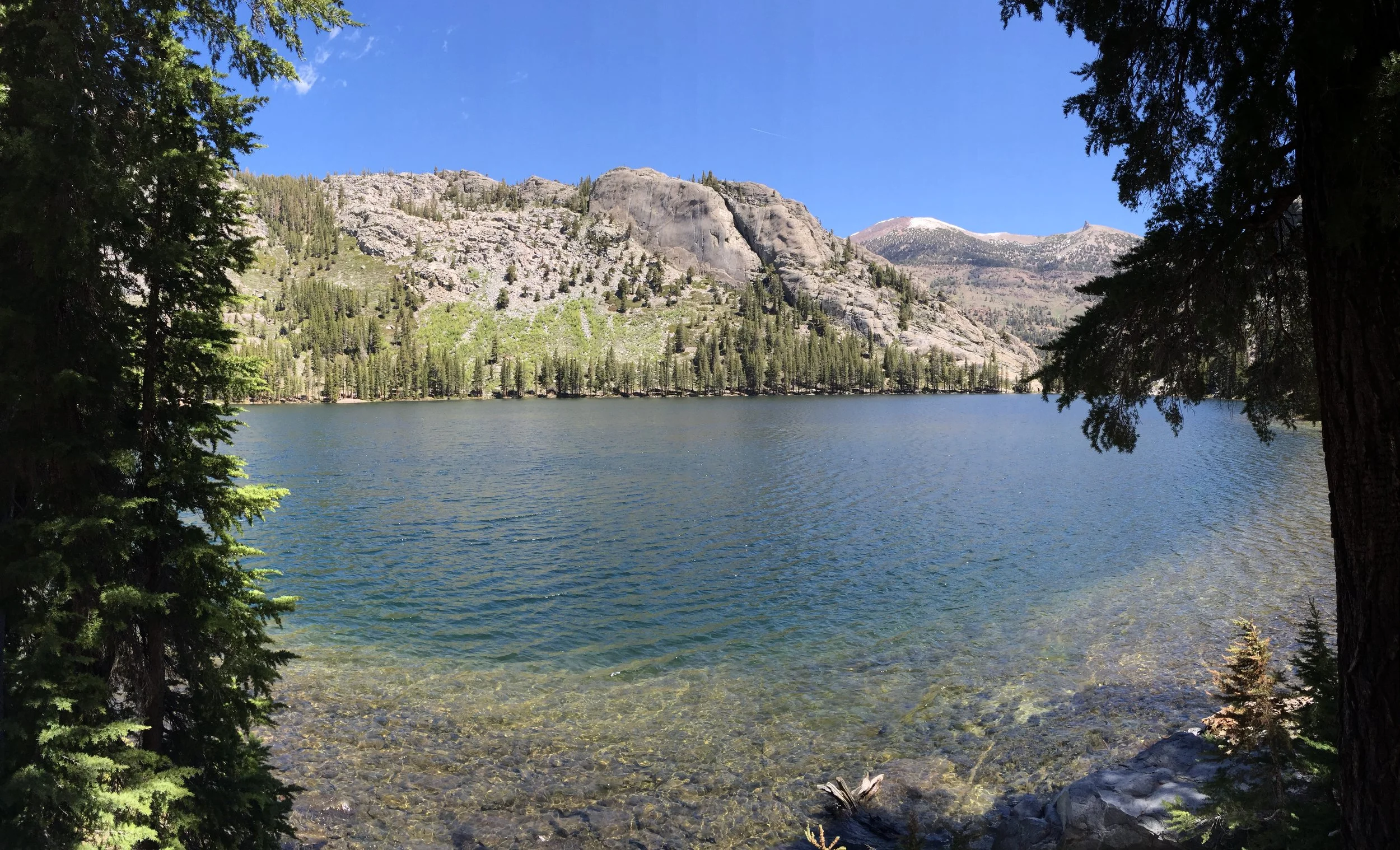
Around 9 miles for the day, I stopped for a small snack and refilled my water at one of two very large lakes.  Together they make up the Twin Lakes of this area.  While refilling, I had an eerie sense that something was watching me.  I didn't know it at the time, but a few hikers left Drakesbad last night and had camped at these lakes and had major issues with a black bear all night long.  If you remember from yesterdays post, this was the area I was wanting to camp, had I left yesterday evening.

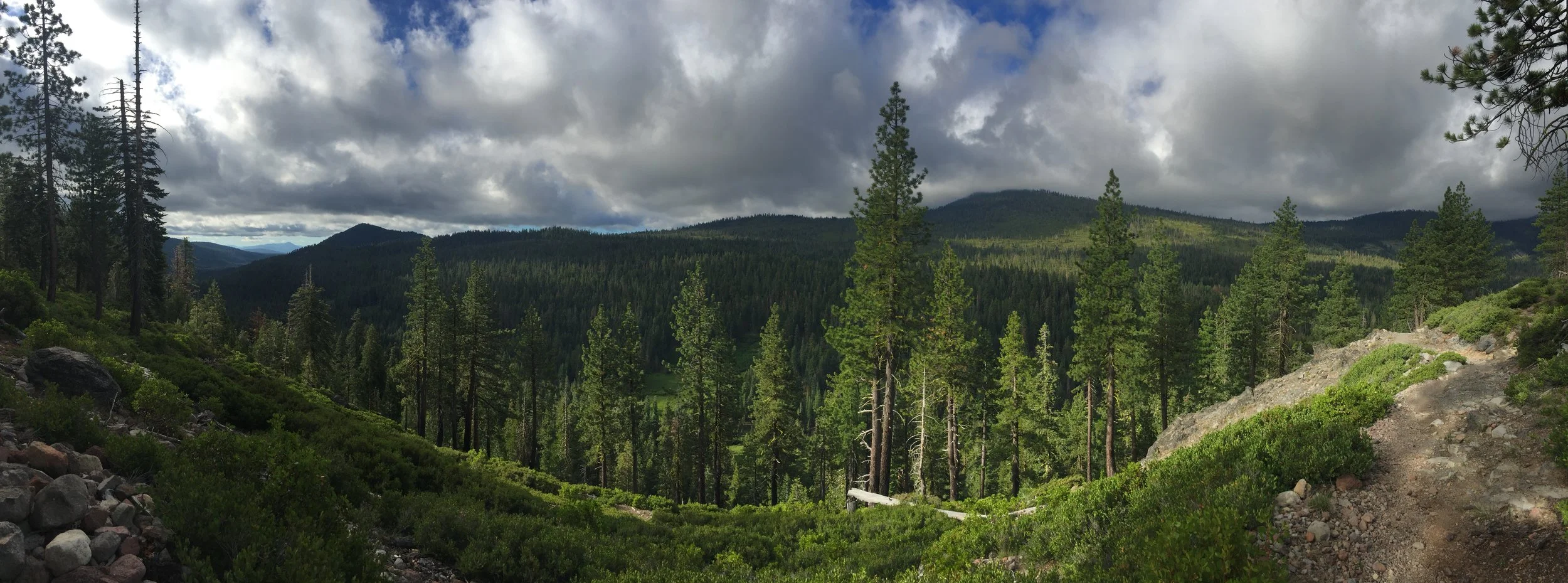
Without seeing anything in the area, I moved along quickly, checking my six every few minutes. Eventually I calmed down and tried to settle into a rhythm.  I was on the second, of few noticeable flat sections on the PCT.  Without any elevation gain, you'd think I'd be able to hike 25 to 30 miles.  But I was never really able to find a rhythm, in fact the slight downhill the trail had seemed to make my legs and feet ache.

Nearing the 20 mile mark, the trail walked along a large river for a short distance and had a few very nice campsites.  Though early in the day, roughly 4:00 pm, I stopped early and relaxed around camp, eating dinner and soaking my legs/feet multiple times in the cold river water.

View fullsize 8789.JPG
View fullsize 8790.JPG
View fullsize 8795.jpg
View fullsize 8794.JPG
View fullsize 8798.JPG
View fullsize 8799.JPG
View fullsize 8801.JPG
View fullsize 8802.JPG
View fullsize 8803.JPG
View fullsize 8805.jpg
View fullsize 8808.JPG
In Pacific Crest Trail Tags Lassen, national, park, twin, lakes, drakesbad, guest, ranch, pct, pacific crest trail, backpacking, Thru hike, thru hiking, camping, flat, trail
Comment

Day 84 - A Long Climb. 1267.8 (20.5)

Kevin Silvernale January 14, 2017

I quite enjoyed the uphills, as one may assume, they provided better and better views the higher I went.  They also didn't really hurt or bother my body.  Where, in contrast, the downhills utterly destroyed my body.  Everything from the tips of my toes, to my top of my neck felt the effects from going downhill.

Read More
In Pacific Crest Trail Tags Quincy, ca, california, northern california, summer, Thru hike, steep, hills, up down, fourth of july, independence day, 4th of july, trail holidays
Comment

Day 78 - A Continuation. 1151.0 (21.3)

Kevin Silvernale January 7, 2017

Today would be a continuation of yesterdays ridge walk.  I did my best to not stop too many times, though I made sure I had a good view for lunch!  Also, I've heard from hikers going southbound that the last snow is at mile 1,225.  Though I've developed a rhythm to get through the snowy areas, it's going to be sweet relief when my feet stay dry all day.

Later in the day, I saw Irish Matt, a thru-hiker who has the same start date as myself. In fact, we rode in the same car to the trail head together.  He tells me his feet really hurt and he thinks something must be wrong with them.  Later we will find out, that was an understatement.  We chatted for a few minutes while enjoying a particularly good view, then talked as we hiked. There were many miles ahead before the end of the day.

It wasn't too long before we went back to hiking at our own paces, both of us figuring we'd see one another in a few hours at camp.  About 1.5 miles prior to my camp, I passed him and most of the group. I wanted to get to a ridge further ahead where I thought I would see a great sunset and sunrise.  Little did I know by walking ahead it would be the beginning of the group splitting up.  I would later find out Skinny Thor walked an additional 2-3 miles beyond me.

I encountered a swarm of mosquitoes in a rather damp area approximately .5 miles prior to camp.  Forcing me to run with my tired legs, I wonder if I made the correct choice in camping locations.  But at the top of the ski slope, I found my site and it had epic panoramic view of the valley below and of the sun setting behind the jagged ridges in the distance.

View fullsize 8545.JPG
View fullsize 8547.JPG
View fullsize 8548.JPG
View fullsize 8549.JPG
View fullsize 8554.JPG
View fullsize 8556.JPG
View fullsize 8555.JPG
View fullsize 8558.JPG
View fullsize 8559.JPG
View fullsize 8562.JPG
View fullsize 8564.JPG
View fullsize 8567.JPG
In Pacific Crest Trail Tags Donner Ski, Ski, donner pass, pct, Thru hike
Comment

Day 64 - JMT Alternate Part 2 and Island Pass. PCT 926.1 (17.8)

Kevin Silvernale December 23, 2016

Mileage Breakdown: 11.3mi JMT Alternate + 3.2mi PCT + 3.0mi Unplanned Detour = 17.8 miles.

Very challenging day.  Though very beautiful, the terrain mainly consisted of steep incline followed by steep decent.  The snow, slush, water and mud added a nice touch to the whole experience.  

About half way into the day, I missed a crucial turn at a fork in the trail.  Instead of leading on toward the PCT and Island pass, I wandered 1.5 miles in the wrong direction.  It was very disheartening, but I had an even longer ways to go before the end of the day, so all I could do was turn around and move on. 

About 100 yards after turning around, I found Butterfingers had followed me down the wrong trail.  The look on her face screamed, "NOOOOO, don't tell me we went the wrong way".  But we had, so together we hiked as quickly as we could to avoid getting into camp before dark.  This also meant we didn't take very many breaks.

The views were gorgeous.  The wind and cooler tempuratures kept me from stopping to take them all in, so I took a ton of pictures which I could appreciate from the comfort of my sleeping bag.  

Island Pass is nothing like the other passes along the PCT/JMT.  more of a rolling hill, I never really knew when I had passed it.  It's shallower slopes held a lot more snow which caused the end of the day to be mainly post holing in the slushy mess.

In camp, we had a large group.  Primarily due to the fact this was the last good campsite before tomorrows pass.  I'll plan on being up bright and early one more time.  Hopefully it will be the last early morning for a while.

8176.JPG
8178.JPG
8180.JPG
8183.JPG
8185.JPG
8187.JPG
8188.JPG
8190.JPG
8192.JPG
8193.JPG
8194.JPG
8195.JPG
8196.JPG
8197.JPG
8199.JPG
8200.JPG
8201.JPG
8203.JPG
8204.JPG
In Pacific Crest Trail Tags PCT, pacific crest trail, 2016, john, JMT, Island Pass, Sierra Nevada, Thru hike
1 Comment